


If you’re not into climbing county highpoints, it’s pretty unlikely that you’ve ever heard of the Raft River Mountains. I certainly hadn’t before deciding I’d climb the highest point in each of Utah’s 29 counties. The Raft Rivers are an east-west-trending mountain range in the extreme northwest corner of Utah, just a few miles south of the Idaho border. The highest point in the range, which also happens to be the highest point in Box Elder County, is Bull Mountain. You can drive to the top of Bull Mountain if you have a 4WD vehicle (I do), but I figured I might as well hike up the thing. I’d seen the pictures of the beautiful cirque up near the top of the mountain, and it alone seemed worth the hike.

Location of Bull Mountain in relation to the rest of Utah
The trail starts on the north side of the mountain at Clear Creek Campground, a free campground with basic campsites and a vault toilet. I pulled into the campground late on the Saturday before Labor Day. Unsurprisingly, there were no spots left. I drove further west from the campground on a dirt road through the bottom of a small canyon and saw that more campsites were interspersed along the sides of the road. I found an empty one less than a mile beyond the campground.
It rained intermittently throughout the night, and the sky was dark and overcast when I woke up the next morning. I resigned myself to probably having to hike in the rain and set off on foot toward the start of the hike, arriving at the trailhead at 8:02 am. The trail started off through dry, deserty scrub, where a dozen cows sat and eyed me warily as I passed. I passed one signed turnoff for the Bull Flat Trail and then, after making it out of the scrub and into the trees, came to a second turnoff fifteen minutes later for the Lake Fork Trail. I kept going straight instead of turning onto the Lake Fork Trail, and I went another fifteen minutes before realizing I needed to turn back and that the Lake Fork Trail was what I wanted.
The Lake Fork Trail started off steep, and a light rain started to fall a few minutes later. I could tell that this trail didn’t get as much use as the main trail. It was much narrower, and I had to climb over and skirt around a few downed trees that blocked the path. The trail followed the left side of the creek before crossing over to the right, and cairns and strips of blue ribbon tied to tree limbs marked the way when the trail itself was faint. At one point I startled a pair of deer, one of which had the largest rack of antlers I’ve ever seen. Sadly, I was too slow with the camera to get a good photo.
Then rain intensified just as the trail petered out alongside the stream. All of the information I’d read online about this route stated that the trail disappeared and that vigorous bushwhacking was required to make it to the cirque. Unwilling to dive headlong into the wet brush, I continued hiking straight up the rocky streambed. While I had to climb up and over a few more downed trees, I had to do very little bushwhacking.
The rain paused right as I emerged into the open bottom of the cirque after about 25 minutes of continuing up the streambed. Cliffs lined most of the cirque’s rim, with the tallest—at least a couple-hundred feet high—right in the middle. That main cliff was straight ahead of me, but I knew I needed to find a trail leading up the lower-angled terrain on the right side of the cirque. I identified it immediately and made a beeline for it, gaining elevation as I did so and enjoying a view of the rest of the cirque that only improved as I went up. I could see now the tiny patches of snow still remaining at the foot of the cliffs and the meadow at the bottom of the cirque that was flanked by dense patches of pine trees. Looking behind me, I noticed that I’d climbed above one set of rain clouds but was still under a second that covered all of the sky overhead.
I climbed up the trail that exits the cirque as quickly as I could to keep myself warm, but the trail ended as soon as it cleared the cirque’s rim. Here the wind picked up, and I had to put on my jacket for the first time. I followed the rim of the cirque up toward where I figured the summit was and had to do some light bushwhacking through thick, shin-high undergrowth. After passing through a large clump of trees and skirting around a barbed-wire fence, I arrived on the broad, treeless summit plateau. It was flat enough that no one point looked significantly higher than the others, but I could see a large cairn with a long stick poking up out of it a couple-hundred yards off and headed toward it.
I arrived at the 9,934-foot summit at 11:19 am, three hours and seventeen minutes after starting. The one-way trail distance from the trailhead to the summit was only about 4 or 5 miles, so I hadn’t made the greatest time, but I was happy to be on top, mostly because it meant that I could turn around an hopefully get out of the wind soon. I signed the summit register and then took a good look around. The views back toward the way I’d come were most obscured by the lower level of clouds but, after walking a short distance south, I could see the Great Salt Lake, the Promontory Mountains, and the northern Wasatch.
Wet snow began to fall just as I was taking my first steps down the mountain. Snow at the beginning of September! Instead of following my ascent route, I descended by taking a few different dirt roads back down to where the trail out of the cirque ended. The snow had morphed into rain at this point, and it continued for most of the way back down to the trailhead. The fog was thick and visibility very low as I entered the lower cloud level, and I made it back to the trailhead just shy of two and a half hours after leaving the summit. The weather really opened up once I got back to camp as driving rain and lightning with thunder kept me holed up in my car for most of the rest of the day.
Overall Thoughts
This wasn’t the heinous bushwhack that I’d been fearing after reading trip reports online. While not a spectacular hike, it was pretty and an enjoyable way to become a bit more familiar with an obscure mountain range. I’m glad I hiked up instead of drove. I ended up doing very little bushwhacking. The cirque would be a pretty amazing place to camp, and I’d love to take some climbing gear up there and spend a few days exploring.
Pics

The Raft River Mountains when driving toward them

An old cabin seen en route to the campground

My campsite

A big cow pie

The trailhead from the main road that goes through the campground

The trail a short distance from the trailhead

The Lake Creek Trail turnoff. This is the way to go!

Looking north from partway up the mountain

Lake Fork Creek

Cairns marking the way

When the trail disappeared, I went straight up the streambed. It wasn’t easy going.

The point where the streambed entered the cirque

The main wall in Bull Mountain Cirque

Looking over to the right side of the cirque. You can see the trail leading out of the cirque to its rim.

The cirque

Looking toward the summit from the point where the trail reaches the rim of the cirque. I went straight through the trees on the way up and skirted around them on the way down.

The cirque

Looking down on the lower cloud layer

The summit plateau

The summit

The summit register

Looking south toward the Great Salt Lake

Summit selfie

A white marker marking the top of the side trail that leads out of the cirque

The cirque

Fog on the descent

An unfortunate creature

A mean-looking hunting arrow

More fog

Cows near the start of the trailhead
Stats and Times
- Date of ascent: September 4, 2016
- Distance: Not exactly sure. I think it’s probably about 4.5 miles each way, and ~9 miles round trip
- Elevation gain: 3650 feet
- Summit elevation: 9,934 feet
—
- 7:38 am – Left camp
- 7:53 am – Entered the campground
- 8:02 am – Started up the trail
- 8:15 am – Arrived at the Bull Flat Trail turnoff/intersection and took the left fork
- 8:31 am – Arrived Lake Creek Trail turnoff and took the left fork (mistake)
- 8:48 am – Realized my mistake and turned around
- 9:02 am – Arrived back at the Lake Creek Trail turnoff and took the trail I should have taken in the first place
- 10:00 am – The trail disappeared, and it started to rain
- 10:26 am – Arrived in the cirque
- 10:31 am – Made it to the start of the obvious trail that exits the cirque
- 11:19 am – Arrived at the summit
- 11:33 am – Left the summit
- 1:33 pm – Arrived back at the main trail at the start of the Lake Creek Trail
- 2:02 pm – Arrived back at the trailhead in the campground
- 2:21 pm – Arrived back at my campsite
Total round trip time from trailhead to trailhead was exactly 6 hours.
Useful Coordinates
- The turnoff for Lake Creek Trail: 41.9373, -113.3267
- Trail disappeared and I started hiking straight up the streambed: 41.9216, -113.3468
- Entered the cirque and left the streambed: 41.9181, -113.3535
- Point where the side trail tops out on the rim of the cirque: 41.9187, -113.3575
Download the zipped gpx file of my hike. Note that in the middle section it stopped recording or something and so shows up as a straight line.
Click the image below to view/download the PDF of the map. Again, note that in the middle section it stopped recording or something and so shows up as a straight line. It shows the line of my descent, which I think is better than the way I went up.
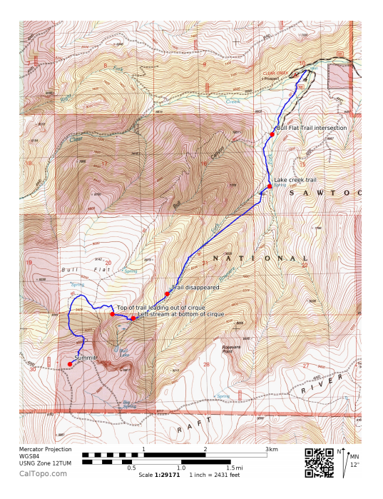
Click to view printable PDF