

It’s been a great few weeks here in Sofia, the capital of Bulgaria. The city is nicer and more pleasant than I expected, and I’ve been very content to just work at home and explore the city when I wanted to get out. I haven’t felt the need to venture outside of the city. But as I realized that my time in the country was coming to an end, I decided I should get out of Sofia and go see something else. And then I thought to myself, “Why not climb the tallest mountain in the country?”
The story
I did some research and it all seemed pretty doable. The mountain is called Musala. According to Summitpost, “The name derives from “Mus Allah” (“the mountain of Allah”), being so named during the period when Bulgaria was part of the Islamic Ottoman Empire.” I thought that was pretty neat. It’s 9,596 feet tall and is located only about 40 miles southeast of Sofia as the crow flies.
The idea of climbing the mountain appealed to me. I wanted to see how out of shape I was. Climbing mountains was a regular occurrence back when I was in Utah, but I hadn’t done any serious hiking since leaving America a year ago. I also wanted to see how my knees would hold up to the hike (I was having knee problems when I left the States). And more than anything, I was just missing the mountains. Going back would be good for the soul.
Mountain climbing is a more involved activity when you’re carless in a foreign country with a foreign language. I left the apartment at 6:40 in the morning, walked to the metro station, rode it one stop, got off, walked to the bus station, found the right bus, waited 20 minutes for the bus to leave, rode the bus for an hour, got off the bus, looked at the schedule for the next bus I needed to catch, saw that I’d have to wait for an hour and a half, realized I didn’t want to wait for an hour and a half, found a taxi, told the driver where I wanted to go, and rode in the taxi to the small ski town of Borovets.
It being mid-summer, there was obviously no skiing going on, but a couple of the lifts and gondolas were still operating. I got on the Yastrebets Gondola for the 25-minute ride up the mountain. It cost 10 lev (~$6 USD) round trip and topped out at 7,770 feet, shaving 3,5000 vertical feet off of the climb I had to do. Awesome.
The weather wasn’t the greatest. It was cold—probably about 45–50 degrees—and foggy and cloudy. I could see the base of Musala a few miles away, but the summit was in the clouds. The hike involved pretty flat walking along a dirt road for a while, some steep hiking up a mountainside, some more flat hiking through a cirque, and then more steep hiking up to the summit. The trail went past several beautiful lakes en route to the top. The weather when I got to to the top was still bad—cold (low 40s/high 30s) and foggy. There were enough breaks in the clouds that I could see the mountains close by, but everything beyond that was covered in clouds.
There were 4 or 5 other people on top when I got there, and the summit itself was rather uninspiring. There were several buildings on top—a hut of some sort, a weather station, what I think was an observatory, etc. They definitely detracted from the beauty of the place, as did the various cast off bits of metal and other associated garbage around them. I hate seeing this kind of stuff on mountain tops. Still, it was great to be on top of a mountain again.
The hike back down was uneventful, as were the string of buses and other means of conveyance required to get back home. I was back in my apartment by 4:30. Overall, it was a good day. It was great to be in the mountains again. Happily, I had no knee problems, and I found that I was in better shape than I thought I’d be in. From the top of the gondola to the top of the mountain is a difference of about 1800 vertical feet and a hiking distance of about 5.5 miles, so I’m happy with my ascent time of almost exactly two hours (which includes about 15 minutes of getting slightly lost). I undoubtedly would have been able to climb it faster a year ago, but I don’t think I would have been a lot faster. I kept up a good pace during the ascent and only really stopped a couple times to snack or add/subtract a layer of clothing.
Nuts and bolts
In case anyone runs across this page in the future and is looking for more concrete info on getting to and climbing the mountain, here is the information I wish I’d had. Everyone else can skip to the photos. First, here were my times:
- 6:40 – Left home
- 7:10 – Arrived at bus station
- 7:30 – Bus departed
- 8:35 – Bus arrived in Samokov
- 8:50 – Arrived in Borovets by taxi
- 9:20 – Was at the top of the gondola (7,770′) and started hiking
- 10:05 – Arrived at Musala Hut, next to the first lake (7,880′)
- 10:32 – Made it to a T in the trail and turned left
- 10:55 – Made it to Everest Hut (8,920′)
- 11:20 – Arrived at the summit (9,596′)
- 11:40 – Left the summit
- 12:45 – Arrived at the lower hut (Musala)
- 13:30 – Arrived back at the top of the gondola
- 14:30 – Minibus from Borovets to Samokov left
- 15:00 – Left on the bus from Samokov to Sofia
- 16:00 – Arrived back at the bus station (Avtogara Yug) in Sofia
- 17:25 – Arrived back home
Now for more details on the transportation, etc. I took the metro to the Joliot-Curie station and then walked south along the road on the east side of the street. After a couple minutes, you’ll reach a railing at the start of a bridge. Right before the bridge are concrete steps leading down (here’s the spot in Google Street View). Go down these steps and you’ll arrive at the Avtogara Yug bus station, which is actually located right under the bridge. Walking from the metro to the bus station only takes about 5 minutes.
At the bus station, look for the bus to Samokov. I hope you can read Cyrillic (look for a minibus to Самоков). A bus leaves roughly every half hour. Here and here are the schedules. The fare was 6 lev ($4.10 USD) as of August 22, 2013. The ride to Samokov took about an hour and five minutes and the final destination of the bus is the bus station in Samokov. Once there, look for the minibus to Borovets (Боровец). Here’s a photo I took of the new bus schedule between Samokov and Borovets (the left column lists Samokov-Borovets times and the right column lists Borovets-Samokov times). I had just missed the previous bus by like 5 minutes and didn’t want to wait around for an hour and a half, so I took a metered taxi (for about 13 lev or $8.88 USD) to the Yastrebets gondola in the little ski town of Borovets. The gondola is 10 lev ($6.83 USD) round trip, and the gondola ride is just under 25 minutes long. From the top of the gondola, walk north down the slope a couple hundred yards to a sign that points the way to Musala. Follow the wide dirt road for a few miles to the big series of buildings at the Musala Hut. This is also where the first lake is. From there, follow the trail that more or less follows the line of tall, skinny pylons. Here’s a map I made of the route I took (and here’s the map on OpenStreetMap without the labels):

A map I made of the Musala hike. From the Musala Hut to the top, there are a few different paths to take. (Click for the larger version.)

The whole route to the summit from the top of the gondola. Musala is the peak just barely left of center.

The sign to Musala

Musala Hut and the buildings around it
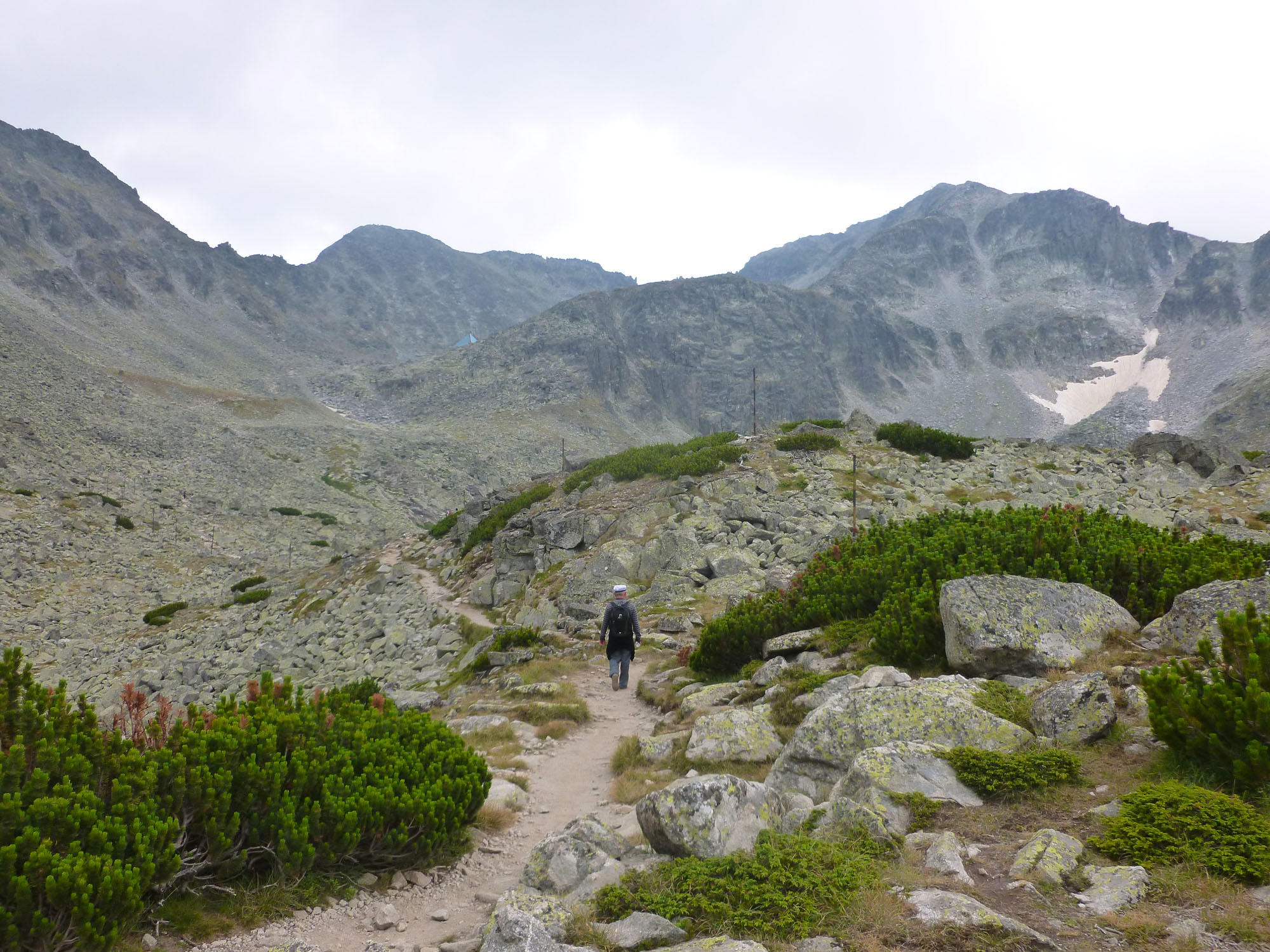
On the trail above Musala Hut. If you look above and to the left of the center, you’ll see a light blue pyramid thing. That’s Everest Hut. The summit of Musala is the obvious mountain on the right.

Looking down on the lake above Musala Hut (where you turn left at the T intersection)

Looking up at the summit from Everest Hut

On the trail below the summit

Looking back from near the summit

Junk on the summit

Another view of some of the buildings on the summit

Swirling mist on the summit

Big cairns below the summit

Summit selfie

The summit marker

Me

Looking back on the route

Looking back on the route, with a few things marked. #1 is the top of the gondola. #2 is the complex of buildings around the Musala hut. #3 is the Everest Hut.

Everest Hut and the cirque around it

Looking back up at the summit with a bit more of the sun out

Everest Hut

The summit

The middle lake that’s at the T junction

The lower lake that’s next to the Musala Hut

A chateau thing being built next to Musala Hut

Nice to be back in the mountains

Looking back. Musala is the peak right of center.