


My goal was to climb Willard Peak, the tallest mountain in Utah’s northern Wasatch Range and the highest point in Weber County. The easiest way up the mountain is to drive up a rough dirt road until you’re about 1000 feet below the summit and then make your way for less than a mile and a half up to the top from there. I wasn’t interested in driving the rough road, so I looked at other options. I decided that the best route would be to climb up Ben Lomond (the mountain about 2 miles south of Willard Peak) and then traverse north to Willard Peak.
Note: I made a video of this hike. Scroll down to the bottom of the post to watch it.

Ben Lomond as seen from Ogden. Willard Peak is the little bump left of Ben Lomond.
That left me with figuring out which route I wanted to take up Ben Lomond. I’d already climbed it via the popular Skyline Trail, and the length (8 miles each way) and popularity (it’s open to even motorized vehicles) of that route made me want to look elsewhere. I decided that at 4.8 miles long each way, the Cutler Basin Trail (a.k.a. Cutler Trail, Cutler Spring Trail) was the way to go.

Ben Lomond (snowy mountain left of center) and Willard Peak (rocky peak right of center) as seen from the drive to the trailhead.
Driving to the trailhead from Ogden meant driving through Ogden Canyon up to Ogden Valley, which I think is one of the most beautiful places in the Wasatch. Mine was the only car at the trailhead, and I set off hiking at 9:09 am. I skirted the large metal gate and spent a few minute walking further down the gravel road before turning left onto a proper footpath that led into the forest. The fall colors were on full display, and I made good progress as the trail climbed steadily. The trail was great—easy to follow, steep enough to make me feel like I was making good progress up the mountain, and not so steep that I had to stop every two minutes.

Near the start of the trail.

Looking out at Ogden Valley

Looking out at Ogden Valley again

Looking up at the upper part of Ben Lomond
I made it to Cutler Spring at just before 10:30 am. This is a very small spring/watering hole that offers amazing views of the east side of Ben Lomond and the southeast face of Willard Peak. Snow started to appear on the trail beyond the spring (remnants of the first fall snowstorm of a week earlier). I pulled my phone out of my pocket to change podcasts just as I was taking care to avoid a particularly wet and muddy section. I slipped, dropped the phone, and added several more cracks to its already-cracked screen. Sigh.

Cutler Spring and Ben Lomond

Looking down on Cutler Spring and Willard Peak
The Cutler Basin Trail met up with the Skyline Trail and the Ben Lomond Peak Trail at a saddle at about 8,700 feet. There are tremendous views from here of Ogden, the Great Salt Lake, and the final thousand feet of Ben Lomond. Two hikers were coming up from the Skyline Trail just as I arrived, and two dirt bikers were getting ready to turn back and head back to the Skyline Trail trailhead. They said the ankle-deep snow above kept them from going further.

Looking toward Ben Lomond from the saddle

Looking down onto Ogden from near the saddle
I encountered several patches of snow on that final slope, but the trail was more often clear of snow than blanketed with it. I passed another pair of hikers and arrived on the summit at 11:36, just shy of 2.5 hours after leaving the trailhead. I stayed on top for only a few minutes (I’d been there before) before continuing on. I found and started following the obvious trail that lead from just below the summit of Ben Lomond toward Willard Peak.

Looking east down the switchbacks just below the summit

Ben Lomond summit selfie

The trail to Willard Peak from just below the Ben Lomond summit

The ridge from partway between Ben Lomond and Willard Peak
About half an hour after leaving the summit of Ben Lomond and just before the trail left the ridgeline to traverse west onto the west face of Willard Peak, I saw the flash of a short gray and white animal up ahead of me. Curious, I went over to where I’d last seen it and followed in the direction I thought it’d gone. I came to a small rock outcropping, saw another flash of white and gray, and heard a hissing sound. I was fairly certain that it was a badger, and my suspicions were confirmed when I looked down into a gap between the rocks and saw a large badger crouched about six feet below me. My primary instinct in these situations is apparently to take a picture before retreating, so I did that before leaving the animal in peace.

The badger. Look at those claws!
I continued to follow the trail as it left the ridgeline and traversed left under the summit of Ben Lomond. No maintained trail goes to the summit of Ben Lomond itself, so I kept my eyes peeled for an easy way to climb straight up back to the summit ridge. I found it just after passing a series of orange-ish cliffs. About 10 minutes of hiking straight up the slope led me to the summit ridge and a faint trail, and another 10 minutes of light scrambling took me to the summit.

Near the point where the trail to Willard Peak cuts left (west) from the ridgeline

The Willard Spires and Willard Bay

I left the trail and headed uphill just after I passed by the bottom of these cliffs

The faint use trail near the summit ridge

The summit

Summit selfie. Ben Lomond is obscured by the clouds in the background.
Clouds had come in to obscure Ben Lomond behind me, but the sky was relatively clear to the north. I spent about half an hour relaxing on top and enjoying the great views and relatively mild conditions before heading back down. The highlight of the descent was seeing a young bull moose near Cutler Spring. Apparently there are moose all over this area. I read one report of hikers seeing eight (!) moose on the hike to the spring.

Hanging out on top of Willard Peak

Antelope Island, the largest island in the Great Salt Lake

Ben Lomond from Willard Peak

The young bull moose I saw on the way down
Overall Thoughts
I think the trail up to Cutler Spring is one of the best in the Wasatch. I really enjoyed it. Every inch of that trail is excellent. The number of hikers I saw between the saddle and the summit of Ben Lomond was a bit of a bummer, but the crowds thinned again as soon as I left Ben Lomond for Willard. Definitely a hike worth doing and a thoroughly enjoyable way to bag the Weber County high point.
Times
- 9:09 am – Left the trailhead
- 10:28 am – Arrived at the Cutler Spring turnoff
- 10:48 am – Arrived at the saddle where all trails converge below the summit
- 11:36 am – Arrived at the summit of Ben Lomond
- 11:40 am – Left the summit of Ben Lomond
- 12:29 am – Left the established trail on the side of Willard Peak and headed straight up
- 12:46 pm – Arrived at the summit of Willard Peak
- 1:17 pm – Left the summit of Willard Peak
- 1:28 pm – Back on the established trail
- 2:12 pm – Back on top of Ben Lomond
- 2:49 pm – Back at the saddle below Ben Lomond
- 3:48 pm – Back on the dirt road
- 4:02 pm – Back at the trailhead
- Total round trip time: 6 hours 53 minutes (including about 35 minutes spent hanging out on the summits)
Stats
- Trailhead to Ben Lomond summit: 4.8 miles with ~3800 feet of elevation gain
- Ben Lomond summit to Willard Peak summit: 2 miles with ~900 feet of elevation loss and ~940 feet of elevation gain
- Total distance: ~13.6 miles
- Total elevation gain: ~5,640 feet
Map, GPS Track, etc.
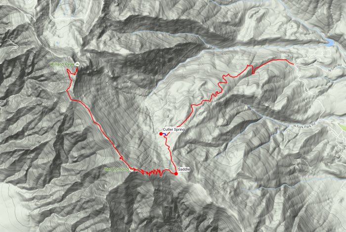
Map of the route. Click it for a printable PDF version.
Click here to download the GPX track. It’s a zipped file that you’ll need to unzip.
Video
I thought it would be fun to make a video of the hike, so I did. Check it out:
Here’s the link directly to YouTube if you can’t see it above.